Last week, we discussed how the Nile was a structuring element of ancient Egyptian life, playing a key role in seasonal agriculture together and as a conduit facilitating trade and (to an extent) centralized control. Because of its importance, the ancient Egyptians took great pains to measure the height of the river using specialized stations called Nilometers.
As instruments that measured the height of the Nile flood, nilometer readings served as a proxy for estimating for estimating the harvest. Particularly low floods were disastrous since usually arable land was not inundated, whereas especially high readings indicated flooding that damaged low lying homes and villages. Many of the most well known Classical authors actually went so far as to describe, in cubits, how high the ideal flood should be!
During Pharaonic times, nilometers are known from a variety of different sites throughout Egyptian territory, from Elephantine to Memphis. Nilometers take a variety of forms, but generally the term refers to specific installations or measuring stations used to gauge the Nile’s height repeatedly rather than individual recordings. There are three particularly prominent types of Nilometers. The earliest attested and simplest example involves marking a recording of the Nile’s height in stone on a cliff face or quay. Sometimes, staircases were built near these features to allow for better access. You can see an example from Elephantine Island here.
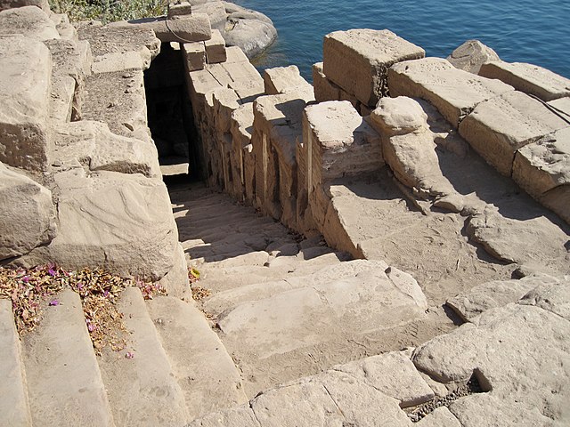
used to measure the water level! Image from Wikimedia Commons.
At the quay of Karnak temple, individual measurements were recorded in stone during the Third Intermediate and Late Periods. Starting at least as early as the Ptolemaic Period, wells were dug (often in the vicinity of temples), and the rising Nile flood could be measured in this way as well.
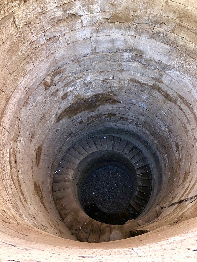
Image from Wikimedia Commons.
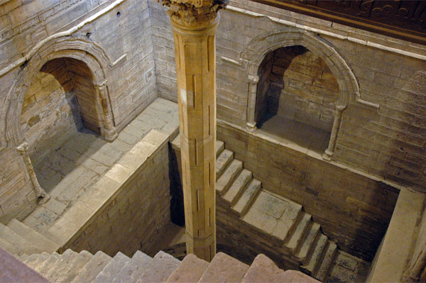
Finally, from the later Roman and Medieval/Islamic periods onward, column Nilometers were sometimes deployed. Column nilometers were engraved with measurements and placed in a location that would be inundated, allowing for easy access to such readings. The most well known example of this type was sited at Roda, near Cairo, though numerous others have been represented in paintings or mosaics. Certainly, earlier nilometers were deployed in the Memphite region, but whether these correspond to the location of the Roda nilometer is uncertain. This installation was used for over 1000 years, and what’s more, we have the good fortune that Islamic Egyptian scholars preserved these records! Temporally, these are the longest set of regular flood readings known in the world.
Challenges Using the Data from Pharaonic Records and the Roda Nilometer
Generally speaking, when nilometer readings were recorded in ancient or Medieval texts, they are in the form of a measurement—usually something like “16 cubits, 3 fingers.” The first, most obvious issue is that not all cubits are identical in size. During the Pharaonic period, cubits tend to measure about 52.5 cm, but vary in later periods. It is only through the painstaking collaboration of Egyptologists, Classicists, and Islamicists that scholars can translate these measurements into absolute measurements in meters and centimeters.
Furthermore, there are environmental changes, as well. The continued deposition of sediments by the Nile together with archaeological processes that accumulate dust and occupational debris have caused the ground level to rise slightly over time. The same can be said for the water table of the Nile itself. Doubtless, geological processes play a role in this as well. So in absolute terms, the level of Karnak temple during the Middle Kingdom was lower than during the Late Period.
Additionally, the Nile does not flood to a uniform height at every location! It is no accident that nilometers from Elephantine and even near Memphis have higher readings than figures reported from Delta sites like Mendes. By the time it reached Mendes, the flood had travelled hundreds of kilometers and fanned out across multiple Nile branches, and local topographical factors play a role as well.
Lastly, it is imperative that we can define the zero point—that is to say, the starting point of our original 16 cubit, 3 finger measurement. Generally speaking this is not so difficult to figure out at preserved Nilometers: the base of the column nilometer at Roda is fairly obvious, and the same might be said for well nilometers, too. However, these zero points might change if the well floor was infilled gradually, or even for more arbitrary reasons. For example, it seems that in the 19th century, the zero point and measuring schema at Roda may have been altered to bring results into line with readings from Aswan. Pharaonic records can be more challenging, as it is not clear whether the zero point reflected the level of the agricultural fields, or the lowest level of the Nile itself.
All this is to say that it is quite challenging to assess what recorded nilometer readings are saying! In the case of Pharaonic flood measurements, inscriptions provide valuable information detailing exceptionally high or low floods. At sites like the Karnak quay, the multitude of readings give a relative sense of how Nile levels fluctuated and which years were particularly successful or disastrous. But the later data from Roda is incomparably useful in this regard. Not only are readings preserved regularly over a nearly 1300 year span, but scholars have a good idea of the changes that were made at this Nilometer over time. Furthermore, Roda continued in use through the 20th century, so we can actually compare these readings with examples from more modern water gauges near Aswan, within the Borderscape Project’s study area! This can be further compared with archaeological data from Elephantine, since years of excavations by our German colleagues at the Deutsches Archäologisches Institut allow us to estimate changes in both maximum flood levels and artificial changes to the island itself over time. In sum, no data set will ever be perfect, but we are fortunate to have such a wide sample size from Roda and a similarly robust archaeological data set from Elephantine to compare with one another. Next week, we will get into how we can use all of this data and represent the results on a map!
Relevant Sources:
Seidlmayer, S. 2001. Historische und Moderne Nilstände. Berlin: Achet Verlag.
Borchardt, L. 1906. Nilmesser und Nilstandsmarken. Berlin: Königliche Akademie der Wissenschaften
Friedman Z. 2008. “Nilometer.” In: Selin H. (eds) Encyclopaedia of the History of Science, Technology, and Medicine in Non-Western Cultures. Springer, Dordrecht